Adding geodata
The Geocoding ![]() action allows you to retrieve latitude and longitude values by providing conventional address information (Address, City, State, Postal Code, Country) using an online service provider.
action allows you to retrieve latitude and longitude values by providing conventional address information (Address, City, State, Postal Code, Country) using an online service provider.
- A valid service connection is used to look up latitude and longitude values.
- Latitude and longitude are output fields in the existing table containing site information
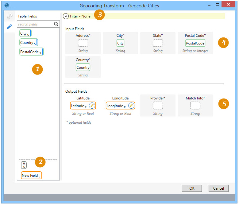
On the Configuration tab:
-
Use Table Fields to define filter and input/output fields.
-
Optionally, define new fields or constants for filters and output fields.
-
Define a filter to limit geocoded records.
-
Drag fields from Table Fields to define the geocoding input fields.
-
Define the geocoding output fields; optionally add the provider and geocoding accuracy information.
The most common application is to obtain latitude and longitude values for locations with address information.
Retrieve geodata for locations
- Drag the Geocoding icon onto the design surface.
- On the Connections tab
 , enter a Name and a Description to identify the action, then specify the target database and geocoding connection:
- Database Connection – Select the database that contains the table for which geodata is being created, or choose New Database Connection to establish a new connection.
- Table Name – Enter the name of the table containing the address information being converted.
- Geodata Connection – Select the connection that contains the key to a valid geodata provider account, or choose New Geodata Connection to establish a new connection.
- Mapset - Visible when PTV has been selected as the geodata connection, this choice allows you to choose the PTV data center from which to receive data. Regional selections include -
- World City Map
- Europe City Map Premium
- North/South America City Map
- Australia City Map Premium
The default is World City Map.
- On the Configuration tab
 :
:- For Input Fields, drag each field to be used for latitude and longitude calculations from Table Fields into the appropriate box in the Input Fields area. You must provide one or more of the following to generate the data -
- City
- State
- Country
- Postal Code
If you specify only the name of a city that exists in more than one location, geodata is generated for the most popular location of that city.
- For Output Fields, drag each field that will receive the latitude and longitude calculations from the Table Fields to the appropriate box in the Output Fields area. You must provide at least the Latitude and Longitude fields. Alternatively, you can drag the New Field icon into one of the Output Fields, and then enter a name for that field.
Optionally, provide a field name for the geodata provider in the Provider field, and field name for the level of geocoding accuracy in the Match Info fields.
- Optionally, use the Filters area to build an expression that more narrowly defines the records for which the geodata is generated.
- For Input Fields, drag each field to be used for latitude and longitude calculations from Table Fields into the appropriate box in the Input Fields area. You must provide one or more of the following to generate the data -
- Click OK.
Geocoding data example

Last modified: Thursday December 19, 2024